

More
Checking your session



The recent disaster in Nepal, triggered by a massive mountainside collapse, underscores the critical need for coordinated regional disaster preparedness and response strategies.
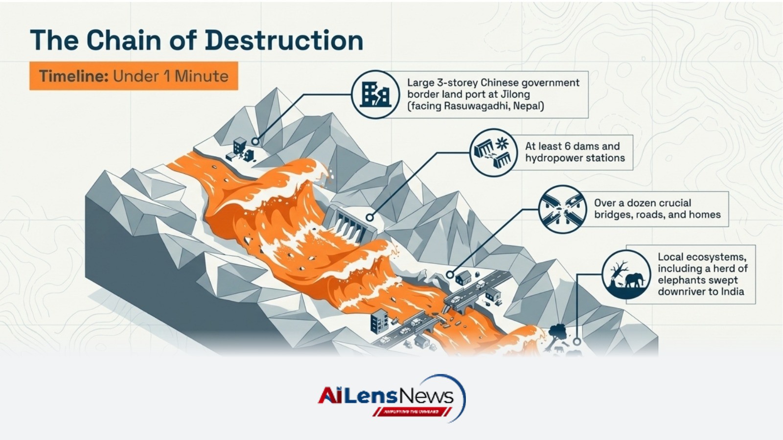
New Delhi, India Aug 30, 2026 ALN: An entire mountainside of ice and rock fell into the Lhende Khola river on the Tibet-Nepal border on the morning of August 26, triggering an earthquake and a flood that rose nine metres, killing hundreds and sweeping away at least six dams and hydropower stations, over a dozen crucial bridges, homes, roads, and even a herd of elephants all the way downriver to India.
There was no rain, just the excessive heat caused by climate change that loosened the ice from the side of the 7,245-metre-high Langtang Lirung peak, until the entire mountainside, including a glacier clinging to it, collapsed into the river flowing some 3,000 metres below. There was no time for any “early” warning as the resultant wall of water, boulders, and mud swept away within a minute the large three-storeyed Chinese government building that used to house the border land port at Jilong, facing Rasuwagadhi on the Nepal side.
A similar hillside collapse had triggered a devastating flood in the Chamoli region of Uttarakhand in February 2021.
And the danger is not over. A day later, debris was still blocking a part of the Lhende Khola, and water was accumulating behind the impromptu dam. More water, and that blockage is likely to give way, leading to a second flood. Authorities have already warned of fresh risk of flooding.
Glaciologists have known for decades that a warming world is leading to faster glacier melting, formation of ever-larger lakes at their snouts, then the lakes bursting out of their unstable moraine bonds and flooding downstream in what is called a glacier lake outburst flood (GLOF). They have been emphasising the need to monitor these lakes, drain them slowly if possible, and install early warning systems for people downstream.
But what can one do if the flash flood is not due to a GLOF but due to this kind of huge mountainside collapse that threatens to become more frequent in the Himalayas as global warming gathers more pace?
“The pace of change is so rapid that current efforts are struggling to keep up,” said Mohammed Farooq Azam, senior cryosphere specialist at the Kathmandu-based International Centre for Integrated Mountain Development (ICIMOD). “Today’s disaster in the Lhende Khola underscores the need for stronger regional collaboration, with governments taking coordinated action to respond to cross-border hazards.”
Just a few months before the latest disaster, researchers from ICIMOD and other organisations had presented a regional cryosphere strategy that would involve all countries sharing the Hindu Kush Himalayas (HKH) – Afghanistan, Bangladesh, Bhutan, China, India, Myanmar, Nepal, and Pakistan – in four activities: consolidating and institutionalising standardised monitoring of glaciers, snow, and permafrost; building sustained capacity through specialised regional capacity-building activities; establishing a Regional HKH CryoHub to ensure usable and policy-relevant data and knowledge services; and prioritising operational decision support services on seasonal snow watch for water and energy planning, hazard monitoring and early warning systems, and basin-scale assessments that link cryosphere trends to risks for people and infrastructure.
The strategy notes, “A basin-representative, quality-assured, and interoperable cryosphere observation and services system can strengthen regional resilience, reduce risks, and amplify the HKH voice in global climate dialogues. This institutional and technical architecture is designed to convert heterogeneous observations into policy-ready knowledge.”
No early warning system would have helped those close downstream of the August 26 mountainside collapse. The flood came too fast. One way to manage this risk is to be able to predict such a disaster with a credible probability level, so that governments can take protective action before a disaster. This would need countries to comprehensively map all icebound slopes above a certain gradient.
This would be a huge task, far tougher than monitoring the expansion of glacial lakes. But that monitoring has improved in recent years due to widespread use of satellite imagery. It is far from an ideal solution — glaciers should be monitored on the ground to get the actual mass balance and to see if they are losing more ice than they are gaining. But it is better than nothing. A monitoring of steep mountain slopes can be started through satellite imagery.
All of this assumes that countries sharing the Hindu Kush Himalayas will be willing to coordinate their cryosphere research efforts and seamlessly share data. Almost all joint research and policy work in the HKH has failed due to the absence of such cooperation. But the events of August 26 have once again underlined that there is no alternative to cooperation.
(The article was first published in Mongabay)
To learn more about the latest developments in Climate Change, stay updated with our exclusive reports and analyses on AILensNews.

A recent study highlights the significant effects of climate change on agricultu…
A recent study highlights the alarming effects of climate change on food securit…
Severe drought conditions across Europe, particularly in Hungary and Romania, ar…
Climate change poses significant risks to global food security, affecting crop y…

Persistent drought and extreme heat this summer have devastated ecosystems and f…