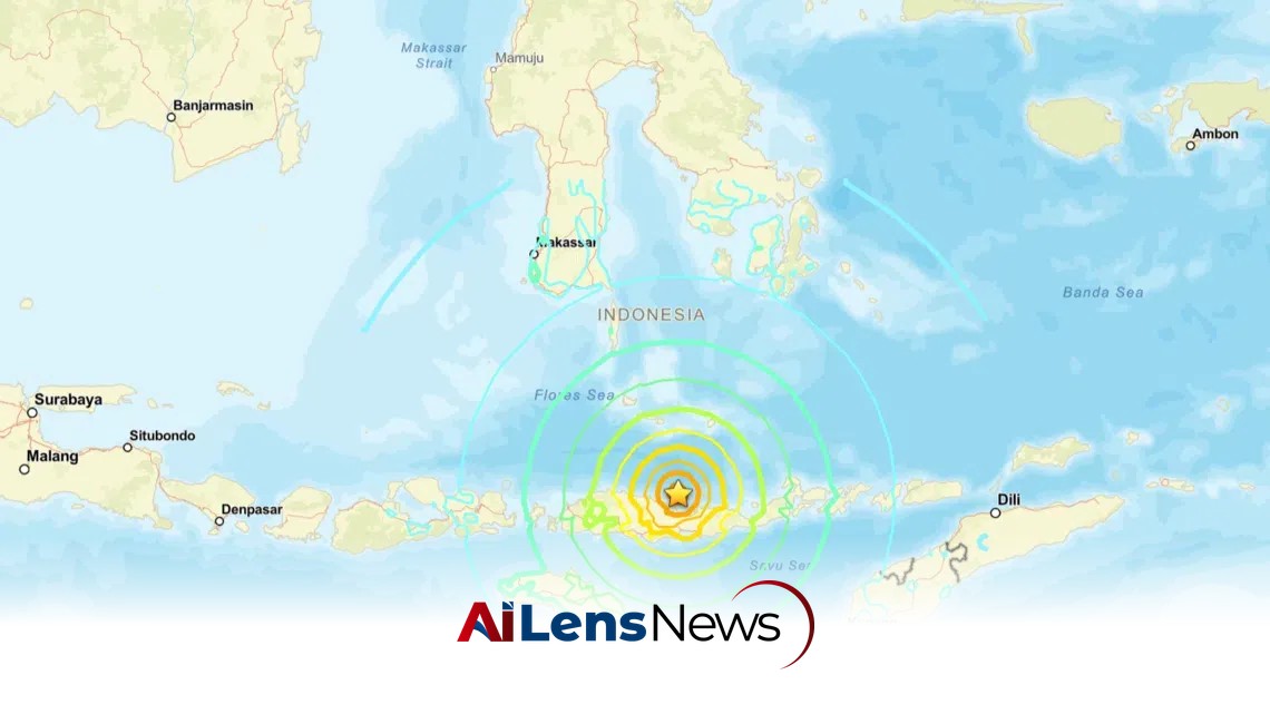


A powerful 7.7-magnitude earthquake hit off the coast of Indonesia's Flores Island, prompting tsunami warnings and aftershocks.
Singapore, Singapore Aug 15, 2026 ALN: JAKARTA - A strong 7.7-magnitude earthquake struck off Indonesia’s Flores island early on August 15, according to the US Geological Survey (USGS). The quake has raised concerns about the safety of the local population and the potential for infrastructure damage, as well as the broader implications for seismic activity in the region.
The epicenter of the quake was located off the north coast of Flores island, approximately 68km north-west of Ende, a significant town on the island. The earthquake occurred at a relatively shallow depth of just 10km, which often results in more intense shaking felt on the surface. Shallow earthquakes can cause more damage compared to deeper ones, as the seismic waves have less distance to travel before reaching the earth's surface.
Following the initial quake, two significant aftershocks were recorded in the same area, measuring 5.6 and 5.9 in magnitude. Aftershocks are common after a major seismic event, and their occurrence can contribute to additional anxiety and potential damage in already affected areas. The aftershocks may also indicate ongoing tectonic activity, which can result in further seismic events in the following days or weeks.
In response to the earthquake, Indonesia’s Meteorology, Climatology, and Geophysics Agency (BMKG) issued a warning regarding the potential for tsunami waves resulting from the quake. Tsunami alerts are a critical part of emergency response in Indonesia, given the country's history of devastating tsunamis triggered by undersea earthquakes. However, Australia’s tsunami warning centre stated that there was “no tsunami threat to the Australian mainland, islands, or territories.” This indicates that while the earthquake was significant, its geographical location and depth mitigated the risk of a tsunami impacting nearby coastal areas.
Indonesia and its neighboring countries frequently experience earthquakes due to their location in the Pacific “Ring of Fire,” an area characterized by intense seismic activity that stretches from Japan through Southeast Asia and across the Pacific basin. This region is home to approximately 75% of the world's active and dormant volcanoes, making it one of the most geologically active areas on the planet. The tectonic plates in this region are constantly shifting, leading to a high frequency of earthquakes and volcanic eruptions.
The region's vulnerability to earthquakes highlights the ongoing geological challenges faced by Indonesia, which is home to numerous active volcanoes and fault lines. Indonesia's geological landscape is shaped by the convergence of several tectonic plates, including the Indo-Australian Plate and the Eurasian Plate. This convergence leads to frequent seismic activity, making earthquake preparedness and response a critical aspect of life in Indonesia.
In the aftermath of the earthquake, local authorities and emergency services are likely to assess the situation, focusing on the safety of residents and the integrity of infrastructure. Given the history of past earthquakes in Indonesia, which have resulted in significant loss of life and property, the government is expected to mobilize resources for emergency response and recovery efforts. Residents are urged to stay alert and prepared for any further seismic activity, which can often follow a major quake.
The psychological impact of such earthquakes on the local population cannot be overlooked. Communities may experience heightened anxiety and fear, particularly in regions that have previously experienced devastating earthquakes or tsunamis. Public education campaigns about earthquake preparedness and response can play a crucial role in mitigating these effects, helping residents to understand what to do in the event of an earthquake.
Internationally, the earthquake may prompt responses from various governments and organizations, particularly those with interests in disaster relief and humanitarian assistance. The global community often monitors significant seismic events in Indonesia due to the potential for humanitarian crises that can arise from natural disasters. Aid organizations may prepare to provide support, including medical assistance, food, and shelter, depending on the severity of the impacts.
In conclusion, the 7.7-magnitude earthquake off Flores island is a stark reminder of the geological volatility of Indonesia and the need for ongoing preparedness and resilience in the face of natural disasters. As the situation develops, it will be crucial for authorities to provide timely information and support to affected communities, while also assessing the broader implications of this seismic event on regional stability and safety.
The Indonesian government has been working to improve its disaster response systems in recent years, recognizing the need for better preparedness in the face of frequent natural disasters. Initiatives to strengthen early warning systems, conduct regular drills, and educate the public about disaster preparedness have become increasingly important. The experience from past earthquakes, such as the devastating 2004 Sumatra earthquake and tsunami, has underscored the importance of these measures.
In addition to local preparedness, international cooperation plays a vital role in disaster response. Countries in the region often collaborate on disaster management strategies, sharing knowledge and resources to enhance their collective resilience. Organizations such as the ASEAN Coordinating Centre for Humanitarian Assistance on disaster management (AHA Centre) facilitate regional cooperation and response efforts, ensuring that countries can work together effectively during crises.
Furthermore, the scientific community continues to study seismic activity in the region to better understand the underlying geological processes and improve predictive models. Advances in technology, such as real-time monitoring systems and improved seismic modeling, are essential for enhancing our understanding of earthquakes and their potential impacts. This research not only aids in immediate response efforts but also contributes to long-term strategies for risk reduction.
As communities begin to recover from the immediate effects of the earthquake, the focus will shift to rebuilding and ensuring that infrastructure is more resilient to future seismic events. The integration of disaster risk reduction measures into urban planning and construction practices will be critical in minimizing the impact of future earthquakes. This may include enforcing stricter building codes, retrofitting existing structures, and ensuring that emergency services are adequately equipped to respond to disasters.
In summary, the recent earthquake off Flores island serves as a crucial reminder of the ongoing challenges faced by Indonesia in managing seismic risks. The combination of geological vulnerability and the need for effective disaster preparedness and response strategies is paramount for safeguarding lives and property. As authorities and communities navigate the aftermath of this event, their experiences will undoubtedly shape future policies and practices aimed at enhancing resilience to natural disasters.
To learn more about the latest developments in World News & International Affairs, stay updated with our exclusive reports and analyses on AiLensNews.