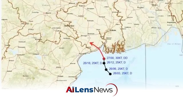


The IMD has issued a flash flood alert as a deep depression over the Bay of Bengal is set to cross the Odisha coast this afternoon, bringing heavy rainfall.
Bhubaneswar, India Jul 27, 2026 ALN: Bhubaneswar: The Depression over northwest Bay of Bengal and adjoining areas of North Odisha-West Bengal coasts intensified into a Deep Depression on Monday. This meteorological development is significant, as it has the potential to bring about severe weather conditions, impacting the lives of thousands of residents in the coastal regions of Odisha and West Bengal.
The system moved very slowly northwards at a speed of 3 kmph during the past 6 hours, intensifying into a deep depression and laying centered at 5:30 am over northwest Bay of Bengal and adjoining areas of West Bengal-North Odisha coasts. It was located about 40 km south of Sagar Island (West Bengal), 70 km east-southeast of Digha (West Bengal), 100 km south of Diamond Harbour (West Bengal), 120 km east-southeast of Balasore (Odisha), and 120 km south-southwest of Canning (West Bengal). This positioning is crucial as it indicates the areas that are likely to be affected first by the impending weather conditions.
The India Meteorological Department (IMD) has indicated that the deep depression is likely to move nearly north-northwestwards and is expected to cross the West Bengal-North Odisha coasts between Baleshwar and Canning around this afternoon. This trajectory suggests that both states will experience the brunt of the storm, with the potential for significant rainfall and wind damage.
Under the influence of the system, heavy to very heavy rainfall may occur at a few places with extremely heavy rainfall at isolated locations in Odisha on July 27. Following this, isolated heavy to very heavy rainfall is expected on July 28, with heavy rainfall projected from July 29 to August 1. This extended period of rainfall raises concerns about waterlogging, landslides, and other weather-related hazards that could affect agriculture, infrastructure, and public safety.
The Met office has issued a red warning for the districts of Sundargarh, Kendujhar, and Mayurbhanj on July 27, indicating that these areas are likely to face the most severe weather conditions. Heavy to very heavy rainfall may also occur at a few places in Baleshwar, Bhadrak, Jajpur, Kendrapada, Jagatsinghpur, Cuttack, Jharsuguda, Baragarh, Sambalpur, Deogarh, Angul, Dhenkanal, Sonepur, Boudh, Kandhamal, Nuapada, Nabarangpur, Balangir, Kalahandi, and Kandhamal. The issuance of these warnings is an essential part of disaster preparedness, allowing local authorities and residents to take necessary precautions.
Heavy rainfall is also likely at a few places in other districts, including Nuapada, Balangir, Kalahandi, Nabarangpur, Rayagada, Koraput, Malkangiri, Gajapati, Ganjam, Puri, Khurda, and Nayagarh. These areas are particularly vulnerable to flooding, given their geography and existing infrastructure, which may not be equipped to handle excessive rainfall in a short period.
In addition to heavy rainfall, squally winds with speeds reaching 50-60 kmph, gusting to 70 kmph, may prevail over North Bay of Bengal and adjoining Odisha-West Bengal-North Andhra Pradesh coasts until the morning of July 28, gradually decreasing thereafter. Squally winds with speeds reaching 40-50 kmph, gusting to 60 kmph, are also likely over central and northeast Bay of Bengal during this period. Such wind speeds can lead to property damage, uprooting of trees, and disruption of power supply.
With incessant rains lashing Odisha for the last two days after a low-pressure system intensified into a depression, the IMD has also issued a low to moderate flash flood risk warning for several districts, including Anugola, Boudh, Baragarh, Deogarh, Kendrapada, Kendujhar, Bhadrak, Cuttack, Jagatsinghpur, Dhenkanal, Rayagada, Sambalpur, Sonepur, and Sundargarh. The risk of flash floods is particularly concerning in these areas, as rapid accumulation of rainfall can lead to swift water rises in rivers and streams, posing a serious threat to life and property.
The implications of this weather system are far-reaching, not only for the immediate areas likely to be affected but also for the broader region. As the system is expected to trigger heavy rains in Chhattisgarh too, the authorities are keeping a close watch on the possible flood situation in Odisha. The cross-border implications of such weather systems are critical, as rainfall in one state can lead to downstream flooding in another. This interconnectedness underscores the importance of regional cooperation and timely sharing of meteorological data among states to mitigate the risks associated with such weather events.
In preparation for the expected weather conditions, local governments and disaster management agencies are likely to activate their emergency response plans. This may include setting up relief camps, deploying rescue teams, and ensuring that essential supplies are available for affected populations. Public advisories will be crucial in guiding residents on safety measures, including avoiding travel during severe weather and seeking higher ground in case of flooding.
Historically, Odisha has been prone to cyclones and heavy rainfall events, making the state more vulnerable to the impacts of climate change. The increasing frequency and intensity of such weather patterns have raised concerns among scientists and policymakers regarding the need for enhanced disaster preparedness and climate resilience strategies. This situation serves as a reminder of the ongoing challenges posed by climate variability in the region.
Moreover, the agricultural sector, which is a significant part of Odisha's economy, stands to be heavily impacted by the anticipated weather conditions. Farmers who are in the midst of the kharif sowing season may face challenges due to waterlogging and crop damage, which could lead to economic repercussions for households dependent on agriculture. The state government may need to consider providing assistance to affected farmers to mitigate the impact of crop loss.
As the situation develops, it will be essential for residents to stay informed through official channels and heed warnings issued by the IMD and local authorities. The coming days will be critical in determining the extent of the impact of this deep depression as it approaches the coast, and the response from both the government and the community will play a vital role in mitigating the effects of this weather system.
In conclusion, the deep depression approaching the Odisha coast is a serious meteorological event that requires immediate attention and action from authorities and residents alike. The potential for heavy rainfall, flooding, and wind damage poses significant risks to life and property. Preparedness measures must be implemented swiftly to minimize the impact of this weather system, and ongoing monitoring will be essential as conditions evolve. The collaboration between various agencies and the public's adherence to safety advisories will be crucial in navigating the challenges posed by this deep depression.
To learn more about the latest developments in Weather & Emergency, stay updated with our exclusive reports and analyses on AiLensNews.