

More
Checking your session
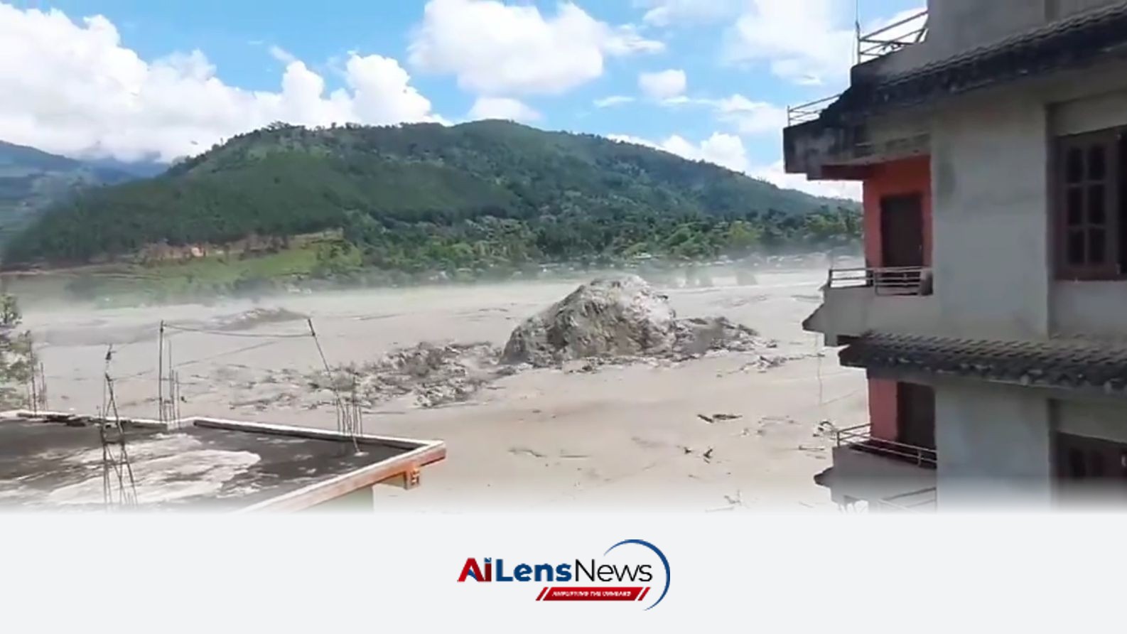



The recent flash flood in Nepal's Rasuwa district serves as a critical alert for the Northeast, highlighting the interconnectedness of Himalayan ecosystems and the urgent need for preparedness.
Shillong, India Aug 27, 2026 ALN: No rain fell over Nepal’s Rasuwa district on the morning of August 26. Nepal’s own Department of Hydrology and Meteorology has confirmed it.
Yet by 9 am, a wall of water and debris had torn down the Bhote Koshi river, sweeping away homes and bridges in Rasuwagadhi and Syabrubesi, burying the Gyirong border post on the Tibetan side, and taking some 430 MW of hydropower offline — about one-eighth of Nepal’s hydropower capacity.
By Wednesday evening, Nepal Police said more than 350 bodies had been recovered, with close to 1,400 people still missing across Nepal and Tibet — among them pilgrims who had gathered near the sacred Gosaikunda lake for Janai Purnima. The figures were still climbing.
A devastating flood on a rainless morning should worry us in the Northeast. Because the mountains that produced it do not end at Nepal’s border.
They run east through Sikkim, Bhutan and Tibet into Arunachal Pradesh — and every mechanism scientists suspect was at work above Rasuwa exists in the catchments that feed the Siang, the Subansiri, the Kameng, the Dibang and the Lohit.
This is not a prediction of disaster. It is a case for paying attention while there is still time to prepare.
What happened above Rasuwa is still being pieced together. A tremor recorded at 8:37 am, initially reported as a magnitude 4.4 earthquake, was reinterpreted by the United States Geological Survey: the seismic energy came not from the earth’s crust but from a massive landslide.
The leading hypothesis, according to the International Centre for Integrated Mountain Development (ICIMOD) and glaciologists at Kathmandu University, is that a collapsing glacier — an avalanche of ice and rock — temporarily dammed the Lhende river high in Tibet.
The impounded water then burst through, arriving in Nepal not as the familiar, gradual rise of a monsoon river, but as a sudden and violent surge.
Here is the detail that should hold our attention: this was the second time in 14 months that the same river was destroyed by water from the same high country.
In July 2025, the Bhote Koshi flooded after a lake perched on a glacier in Tibet burst — a lake that appeared on no hazard inventory anywhere. Satellite imagery examined by ICIMOD showed it had begun as a small meltwater pond in December 2024 and grown, in barely six months, into a body of water large enough to kill.
ICIMOD’s scientists say floods of glacial origin, once expected in the Hindu Kush Himalaya perhaps once in five to ten years, are now arriving in clusters — three in May and June of 2025 alone.
Around 200 of the region’s glacial lakes are already classified as dangerous. The newer threat is the lakes that are not classified at all, because six months ago they did not exist.
Arunachal Pradesh has 1,532 glacial lakes, according to the standard scientific inventory. Of these, the National Disaster Management Authority (NDMA) has identified 27 as high-risk: six in Tawang, sixteen in Dibang Valley, three in Anjaw, and one each in Kurung Kumey and Shi Yomi. Expedition teams physically assessed six of them, in Tawang and Dibang Valley, in late 2024.
The lakes are not static. Studies of the Mago basin in Tawang show its glacial lakes expanding at over 3 percent a year; lakes in the Subansiri and Dibang basins are growing too, as the glaciers above them shrink.
Nor is the danger hypothetical for the Northeast. In October 2023, a slope of frozen debris collapsed into South Lhonak lake in Sikkim, sending a wave over its moraine wall.
The resulting flood killed at least over 170 people, left 74 missing, and destroyed the 1,200 MW Teesta-III dam at Chungthang. A warning system for that lake was under installation and would have bought roughly 90 minutes. It was not yet operational.
There are other examples too.
In June 2000, a lake formed by a landslide in Tibet’s Yigong valley burst and sent a flood 500 km down the Siang — as the Brahmaputra is known in Arunachal — by some published estimates destroying 20 bridges and leaving around 50,000 people homeless around Pasighat.
Geologists have found evidence of eight such damming events at the same Tibetan gorge over six millennia. These are not freak occurrences. They are a recurring feature of the river system that 40 percent of flood-prone Assam lives beside.
And this monsoon has already shown how exposed the state’s steep catchments are. Flash floods and cloudbursts have touched all 27 districts and nearly 600 villages in Arunachal this year — from NEEPCO Colony and Possa in Keyi Panyor in June to Ledum and Korang in East Siang — affecting close to 1.5 lakh people, by state disaster-management figures reported in late July.
As reported in July, Arunachal’s floods are becoming more destructive, and the reasons are structural: the Siang, Subansiri, Kameng, Dibang and Lohit fall from the Tibetan plateau to the Assam plains — a drop of several thousand meters over a few hundred kilometers that gives them enormous destructive energy.
The most sobering fact from Rasuwa is not geological. It is administrative.
No warning reached Nepal through any formal bilateral channel. The country’s own flood forecasters learned of the surge only after it was already inside Nepal — according to a Kathmandu Post reconstruction, word reached district authorities roughly 45 minutes after the collapse, much of it from villagers who saw the water coming. The first scientific information from the Chinese side arrived second-hand, routed through ICIMOD.
India should read that closely, because our own upstream arrangement is in worse shape. The memorandum under which China shared Brahmaputra flood-season data has lapsed, and no regular data has been transmitted since around 2022.
After talks in Delhi last year, Beijing committed only to sharing hydrological information in “emergency situations based on humanitarian considerations.” For a flood that travels from Tibet to the Siang valley in hours, an emergency notification after the fact is no warning at all.
There is a nearer-term test. India and China have agreed to hold the next Expert Level Mechanism meeting on trans-border rivers in September 2026 — announced, as it happens, on the very day the Bhote Koshi flooded.
To be fair, India has not been idle. The Central Water Commission now monitors 2,485 glacial lakes across Himalayan basins by satellite every June.
To learn more about the latest developments in Climate Change, stay updated with our exclusive reports and analyses on AILensNews.
The Brahmaputra River system is crucial to Assam's ecology and communities, yet …

faces a staggering 58% monsoon deficit, jeopardizing its rain-fed agriculture an…

A new study reveals that rising temperatures and altered monsoon patterns are je…

Meghalaya has intensified efforts against illegal industries, demolishing 72 cok…
Dr. Bibhab Kumar Talukdar emphasizes the critical link between biodiversity cons…